


Pakkoku Airfield - major military construction.
The Burmese Junta is looking for more ways to inflict terror.

After drastically increasing their airstrikes following months of terminal losses on the ground, the Burmese military is seeking to expand the disused civilian Pakkoku Airport into a military airfield for attacks in Arakan/Rakhine and Chin states.
Satellite imagery from Sentinel-2 and Planet reveals significant military construction around the site of the Pakkoku Airport. It highlights the need for international efforts to hinder the Junta’s systematic campaign of aerial terror against civilian targets and the need for genuine increase in civilian protection measures from all international actors.


Satellite imagery (Sentinel-2) of Pakkoku Airfield in November 2023 (top) and November 2024 (bottom). In these maps, east is up.
Since nation-wide resistance to the 2021 Military Coup in Myanmar sparked widespread conflict, the Burmese junta has extensively conducted airstrikes on the Resistance-stronghold of Chin State, with local human rights organisations tallying over 500 airstrikes across Chin, destroying scores of schools and churches and killing over 100, mostly civilians.
In Arakan/Rakhine, the number of airstrikes has escalated even more dramatically as a thorough offensive by the Arakan Army has captured much of the state from Junta forces. From May - August this year, the Junta conducted over 230 airstrikes against Arakan/Rakhine state, averaging nearly two airstrikes per day.
Currently, airstrikes conducted in Arakan/Rakhine are conducted from Tada-U airbase, attached to the Mandalay International Airport, this new airfield would cut over 150km from the distance for sorties in Arakan/Rakhine. Airstrikes in Chin are conducted from either Monywa or Tada-U Airbase, with the Pakkoku Airfield which is currently under construction cutting over 100km off the round-trip distance from Tada-U (though Monywa is closer).
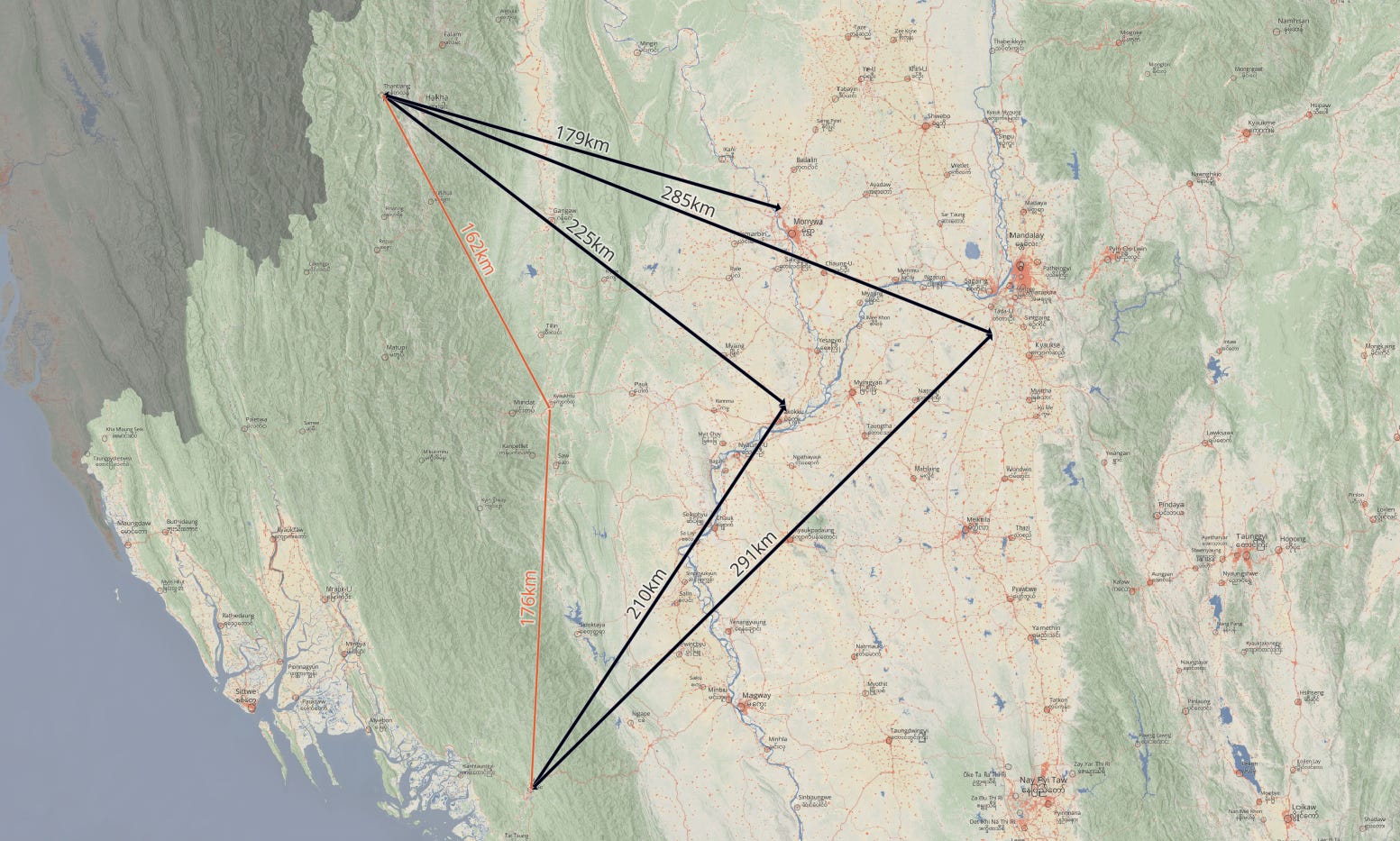
Both states were also previously attacked by sorties leaving from the smaller Kyaukhtu Airbase in Saw township (shown by the smaller orange lines in the map above), however, recent gains by the Resistance in the Magway countryside made it much more difficult to supply the base with jet-fuel and conduct sorties out of the base.
Given the rate of sorties and the ageing Junta aircraft, the reduction in flight distance (especially to Arakan/Rakhine) rapidly adds up, and could potentially reduce significant fatigue on the airframes. (If someone with more expertise than me in aircraft maintenance wants to help quantify this further please get in touch and I’ll add in your comments).
A sergeant who defected to the resistance in 2021 told the Irrawaddy “[The] plan is to switch to Pakokku because it’s difficult to transport aviation fuel to Kyaukhtu now,” he said. “The regime previously used Kyaukhtu Airport to conduct air attacks on Rakhine and Chin states and needs Pakokku Airport because of ongoing fighting in [Chin State’s] Mindat.”
Pakkoku Airport was opened in 2005 on land that was confiscated from local farmers in 2002, but had mostly fallen out of use as airlines travelling to Bagan preferred to use the nearby Nyaung-U Airport.
Other details in the Irrawaddy reporting are less accurate - namely the dimensions estimated by local battlefield Resistance sources to the paper. But luckily, with satellite imagery, we can thoroughly quantify the renovations and compare them to other bases.

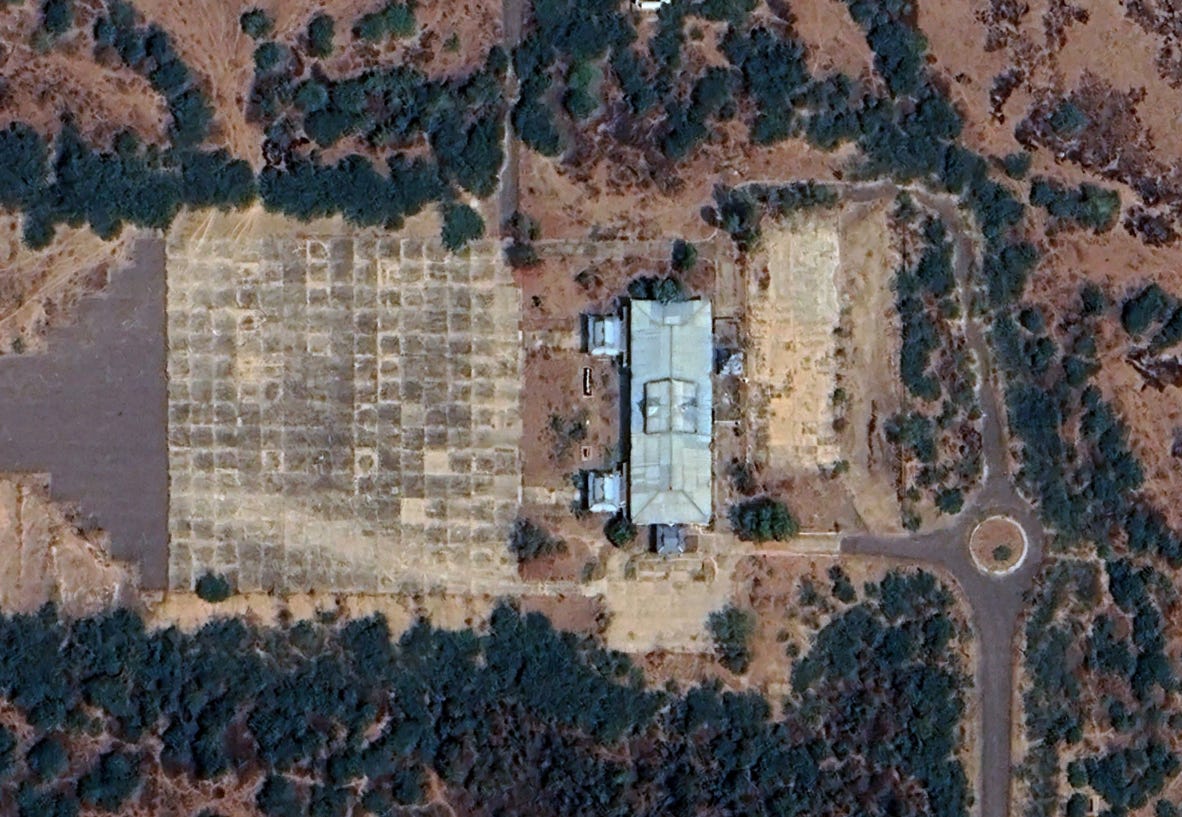
The most significant change appears to be to the width of the airstrip, going from around 30m to 120m. Now this is a massively wide airstrip (by comparison the runway at Tada-U airbase is 60m wide), so it’s possible that in the final construction, the runway will not end up the full 120m wide, but it is clear that there is a substantial effort going in to making this runway wider.

The length appears to be less drastically changed, adding a maximum of 300m to make the runway around 3km long. Tada-U, by comparison, is around 4.4km in length.
There is also the clear inclusion of a roughly 10 km-long security fence around the entire perimeter, likely in an attempt to protect the location from Resistance assaults.

Additionally, around 6 new hangers appear to have been constructed in Planet satellite imagery from October. These are shown by the shield outline in the satellite image above.
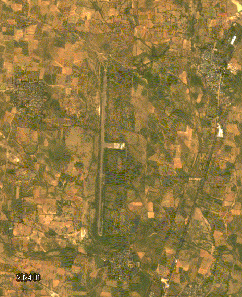
Construction on the airfield only began in August - according to satellite imagery, with high-resolution imagery from March this year showing an extremely derelict airport.
Satellite imagery from March 2024.
The rate of this construction is dramatic and shows the strategic importance that the Junta places on its ability to easily conduct airstrikes to defend their rapidly deteriorating presence in Arakan and Chin States.
However, given the recent gains by the Arakan Army and various Chin groups, by the time the airfield is complete - it might be too late to be of much use for anything other than retaliatory terror attacks against the civilian population in areas under Resistance control.
A timelapse of monthly Planet imagery showing the renovations to the airfield.