
Tracking recent, free satellite imagery of Myanmar
If Google won't, I will.

Recent, high-quality satellite imagery provides a transformative tool for monitoring conflict in hard-to-access areas, offering numerous benefits across operational, strategic, and humanitarian dimensions. The fidelity of analysis with access to recent imagery is remarkable compared to those primarily based on media reports. This post will share a dataset I have created to monitor recently acquired Google satellite imagery and the methodology behind it.
Until recently, Google Earth offered a layer showing the footprints of recently acquired satellite imagery that had been ingested into the platform, however, a recent update late last year removed that option.
As part of my routine tracking of the situation in Myanmar I have been regularly finding and noting imagery from across Burma captured over the 2024/2025 dry season (September - May. Roughly). In total, I have come across over 100 satellite imagery scenes from across Myanmar that show the latest developments, including some as recent as January 2nd 2025.
To see the exact footprints of these scenes for any conflict-tracking of humanitarian needs, they are available (and will be updated) at THIS Google MyMap, which can be exported as a kml and loaded into Google Earth. It is important to note that there is a considerable delay between when imagery is added to Google Earth and when it is incorporated into the online Google Maps imagery tiles, so you will need to use Google Earth to view the latest imagery in many cases.
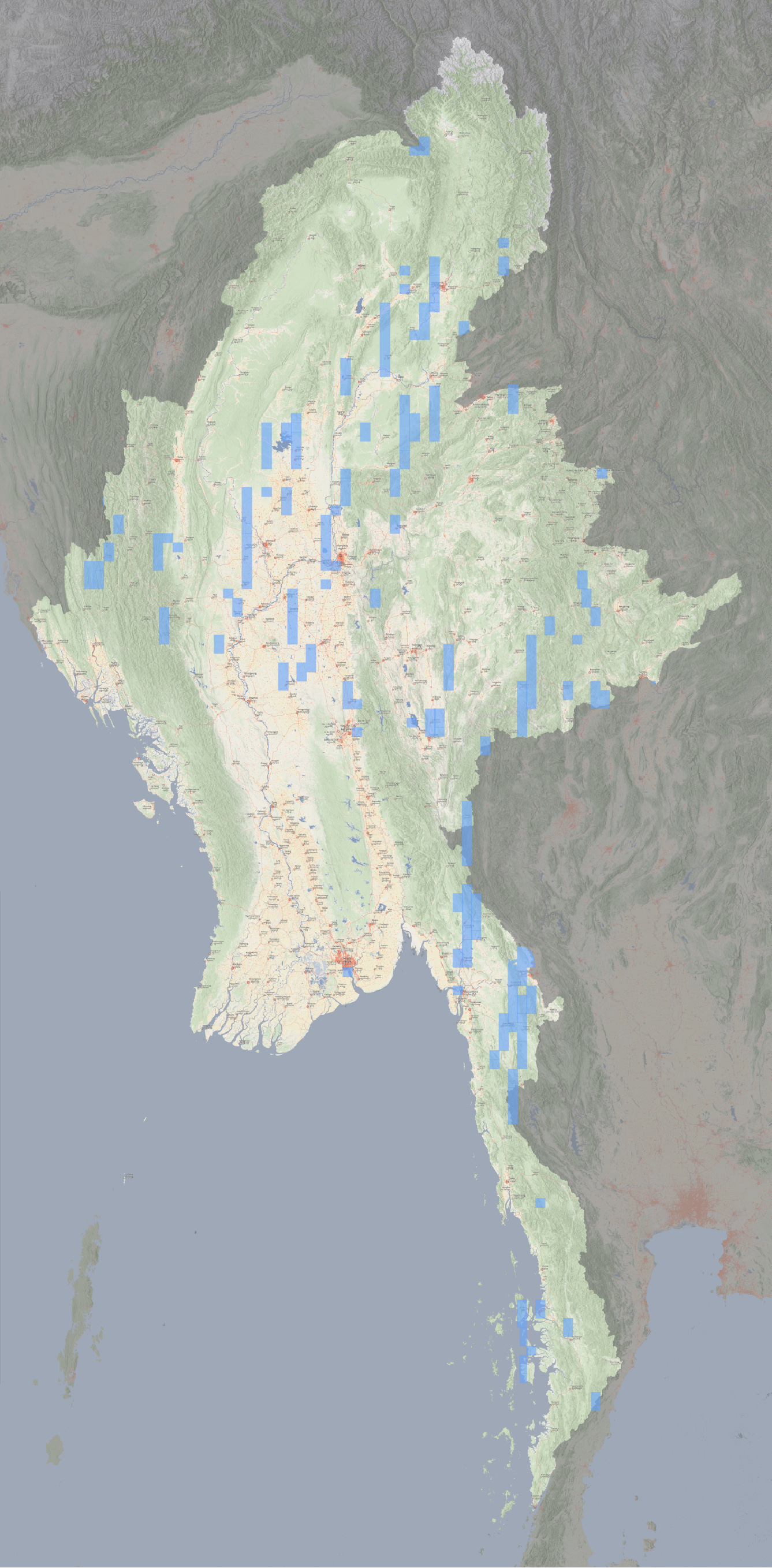
The footprint of recently acquired satellite imagery across Burma in Google Earth.
In total, these scenes cover almost 55,000 square kilometres of the country (around 8% of the total land area), with particular concentrations of imagery in Karen state, parts of central Sagaing, Chin and lower Kachin.
The extent of recent imagery will by definition grow over the coming months, and I will attempt to keep the Google MyMap updated as I find new scenes.
Please contact me on Twitter of Bluesky if you find additional scenes that I have missed.
A (somewhat systematic) method for finding recent imagery.
With Google retiring the ability to display recently captured imagery, there are several conflict zones globally that could benefit from similar efforts to discover newly added imagery. This is made especially so given Google has recently switched to using Airbus satellite imagery instead of Maxar, allowing them to vastly increase the footprint of new imagery for the same cost (and only barely sacrifising any quality).
Analysis in places like Sudan, Armenia and Haiti, to name a few, would be helped by such attempts.
Below is the method that I used to find these footprints in Myanmar, so that they can be replicated anywhere around the globe. and please let me know if there are any API backends or automatic scraping I could use instead.
Ad-hoc discoveries. I’m on Google Earth a lot, scrolling around and geolocating recent events. I keep the file of late-2024 footprints in Google Earth, and if i ever come across new imagery, I will add it into the file.
Systematically searching towns. I also have a file with all the cities and towns across Burma (around 550 total) ordered by the administrative rank. I will rapidly click-through these points and watch the latest available imagery date on Google Earth Pro, likewise marking any new scenes.
Random Points. In addition to this, I create files of (around 500) random points across the country - with new points each time I try - to then do the same with.
Manually panning. (This is a good time to put on a podcast or audiobook). When I find spare time, I will also start randomly panning around the country on Google Earth Pro to check the latest imagery dates. This is best done with at a view-altitude of around 25km as this gives the largest footprint before the imagery transitions to the annual Landsat composites that Google uses for lower zooms. I do this with the Historical Imagery panel open and set to around May 2024 and then pan until the arrow indicating there is more recent imagery becomes white (see the below picture). As satellite imagery scenes generally extend further north-south than east-west, it is more efficient to mostly pan horizontally. Sometimes I do this in a deliberate grid moving E/W until I reach a border, panning N/S and repeating, other times it is a more casual, slightly diagonal, pan.
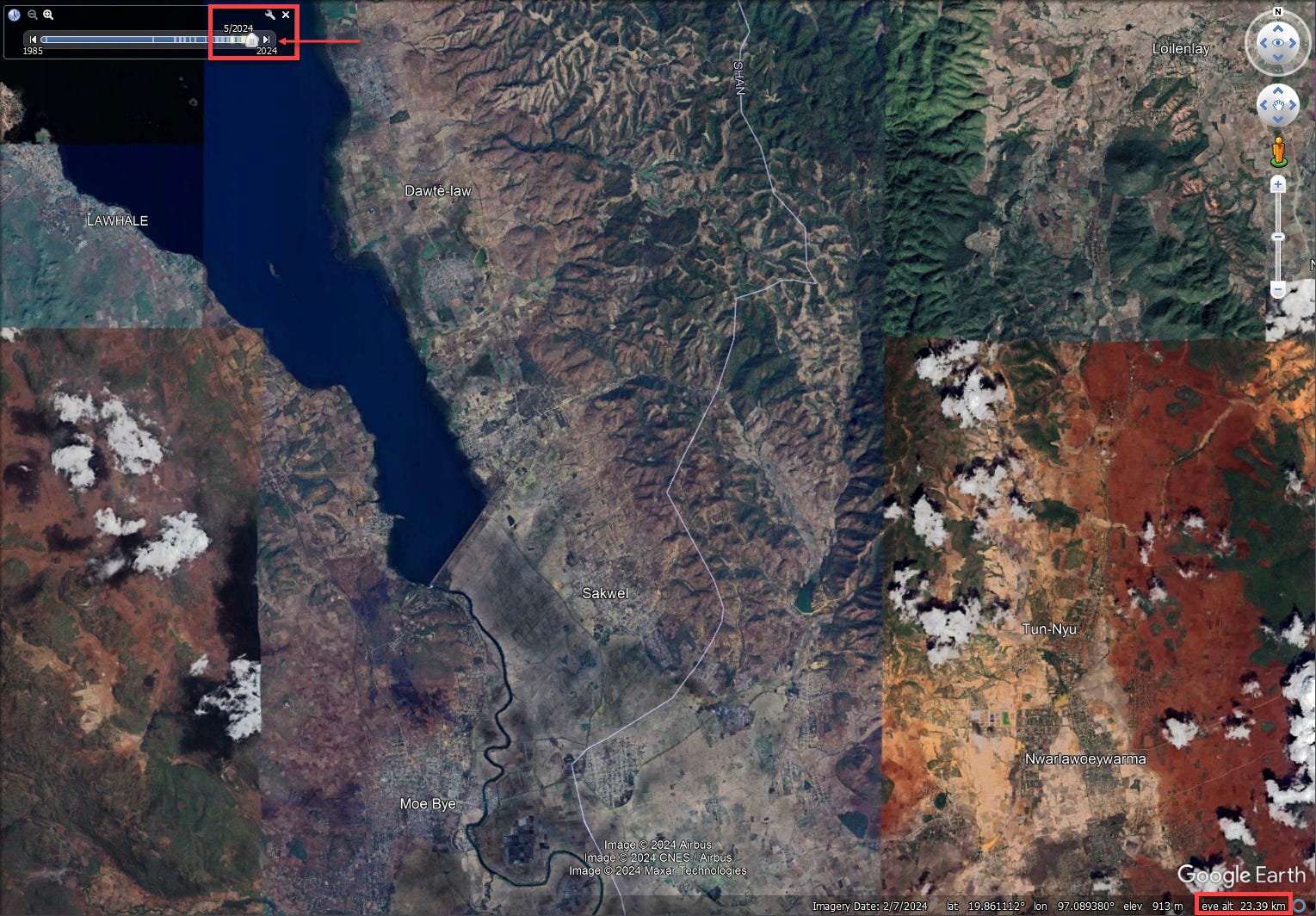
The Google Earth Pro interface showing the timeline panel, the white arrow suggesting newer imagery and the “eye-alt” of around 25km.
If you do undertake similar efforts in other parts of the world, please let me know and share your findings and I’ll work at maintaining a repository of all efforts being made to track recent imagery.
I also plan on doing some deep-dives into particularly interesting recent scenes that I have come across (the imagery from the Asia Highway near Myawaddy and around Kantbalu is particuarly interesting), but that will have to wait for another time.
Happy snooping everyone.